


The Road That Defies the Ocean: Inside the US' Famous 'Floating' Highway
Discover America's most extraordinary overwater highways, the Chesapeake Bay Bridge-Tunnel and Lake Pontchartrain Causeway. Learn how they were built, what it's like to drive them, and why they remain engineering icons.
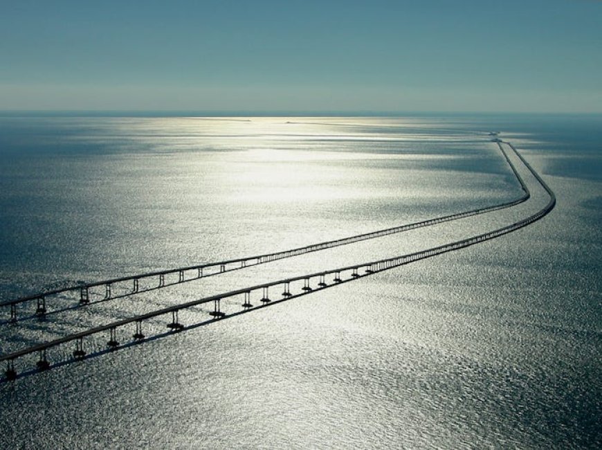
Table of Contents
- Introduction: A Highway Unlike Any Other
- What Is a Floating Highway?
- The Chesapeake Bay Bridge-Tunnel: America's Crown Jewel
- The Lake Pontchartrain Causeway: Longest Over Water
- How These Engineering Marvels Actually Work
- The Construction Story: Blood, Steel, and Saltwater
- Driving the Experience: What It Feels Like Behind the Wheel
- Environmental Challenges and Sustainability Efforts
- Safety, Storms, and the Elements
- Why These Roads Matter: Economic and Cultural Impact
- Visiting Tips: Everything You Need to Know Before You Drive
- Conclusion: Roads Built on Faith and Engineering
-
Introduction: A Highway Unlike Any Other
Picture this: you're driving at highway speed, water stretching endlessly on every side, no land in sight, sky meeting ocean at the horizon in every direction. The road beneath you doesn't sit on solid ground, it rests on water, held aloft by nothing more than concrete, steel, and human ingenuity. You are, in every practical sense, driving across the ocean.
This is not science fiction. It is the reality of travelling America's most extraordinary roads, highways that don't just cross bodies of water, but appear to float atop them.
The United States is home to some of the world's most breathtaking and technically complex overwater roadways. These structures blur the line between bridge and road, between land and sea, and they stand as proof that when human ambition meets engineering brilliance, even the ocean becomes navigable by car. Whether you're a road trip enthusiast, a civil engineering admirer, or simply someone who loves a story where humans do the seemingly impossible, America's floating highways deserve a place on your must-know list.
-
What Is a Floating Highway?
Before we dive into specific structures, it's worth understanding what makes a highway "floating" because technically, none of these roads are literally buoyant.
A floating highway (or overwater highway) is a roadway built across a large body of water using a combination of bridges, tunnels, artificial islands, and causeway-style embankments. The "floating" impression comes from driving along a narrow strip of road with water on both sides, often so far from shore that solid land disappears completely from view.
There are several structural approaches used in these projects:
- Fixed elevated bridges: Supported by underwater piers driven deep into the seabed
- Floating bridge segments: Used in some designs where pontoons or hollow concrete sections actually rest on the water surface
- Underwater tunnels: Used when water is too deep or shipping lanes must remain clear
- Artificial islands: Man-made landmasses used as transition points between bridge and tunnel sections
The most dramatic of America's overwater roads combine multiple techniques, creating a driving experience that feels genuinely otherworldly.
-
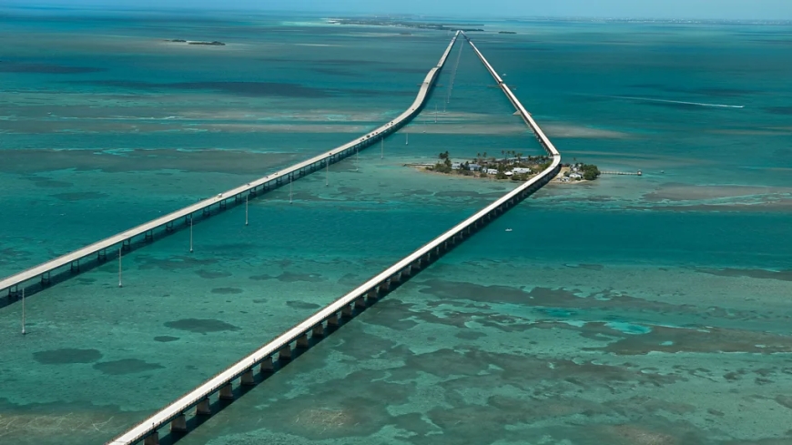
The Chesapeake Bay Bridge-Tunnel: America's Crown Jewel
If there is one overwater road that best captures the imagination, it is the Chesapeake Bay Bridge-Tunnel in Virginia. Stretching approximately 17.6 miles across the mouth of the Chesapeake Bay, this structure connects Virginia Beach and the Delmarva Peninsula, a journey that would otherwise require a 95-mile detour around the bay.
What makes the Chesapeake Bay Bridge-Tunnel genuinely unique is its multi-format design. Rather than simply being one long bridge, the route includes:
- Two mile-long tunnels that plunge beneath the shipping channel
- High-rise bridge spans that rise above the water
- Low-level trestle sections that seem to skim the ocean surface
- Four artificial islands built to serve as transition points
The tunnels drop vehicles below the waterline to allow massive cargo ships to pass overhead on the surface, a detail that feels almost cinematic when you're inside, knowing that ocean tankers are sailing above you.
Opened in 1964 and expanded with a second parallel tunnel in the mid-1990s, the Chesapeake Bay Bridge-Tunnel has been called one of the Seven Engineering Wonders of the Modern World. On a clear day, the views are staggering. On a stormy one, they're humbling. Either way, you don't forget it.
-
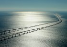
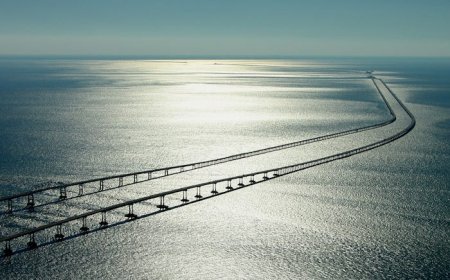
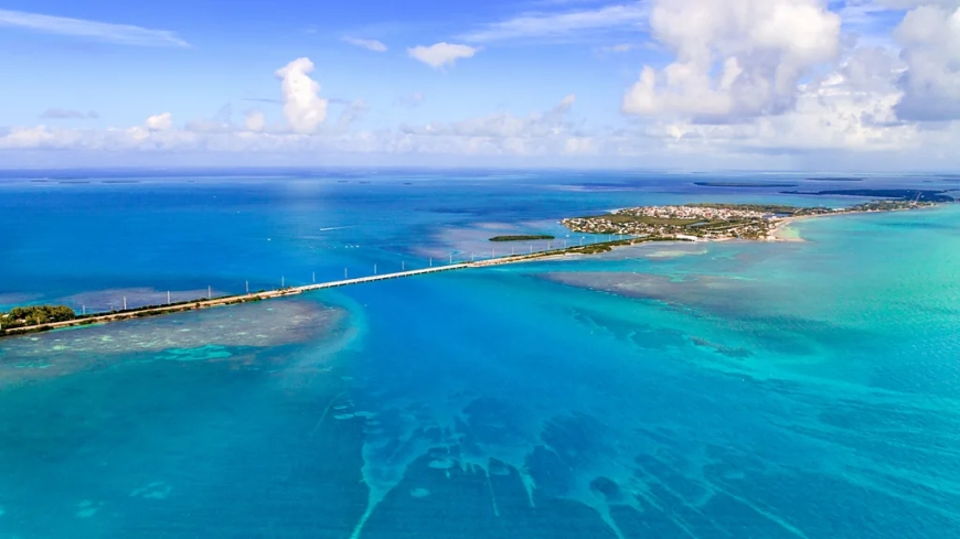
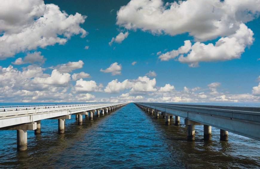
The Lake Pontchartrain Causeway: Longest Over Water
For sheer length, no American overwater road matches the Lake Pontchartrain Causeway in Louisiana. At approximately 24 miles (38.6 kilometres), it holds the record as the world's longest bridge over water by total length, crossing Lake Pontchartrain to connect Metairie (a suburb of New Orleans) to Mandeville on the north shore.
Unlike the Chesapeake Bay structure's dramatic engineering theatre, the Pontchartrain Causeway is almost meditative in its simplicity. Two parallel bridge spans, one for northbound traffic, one for southbound, run in a dead-straight line across the lake. There are no tunnels, no artificial islands, and for approximately eight miles in the middle of the crossing, no land is visible in any direction.
That eight-mile stretch of total water-horizon isolation is what earns the causeway its "floating highway" reputation in the minds of those who've driven it. The psychological experience of being on a two-lane road with nothing but lake on all sides triggers something primal, a mix of freedom and vulnerability that few roads in the world can replicate.
The causeway opened its first span in 1956 and added the second parallel span in 1969. Tolls are collected (southbound only as of recent years), and the crossing takes roughly 30 minutes at normal speed.
-
How These Engineering Marvels Actually Work
The construction and ongoing stability of overwater highways involves solving problems that don't exist on dry land.
Foundation Systems
For structures like the Chesapeake Bay Bridge-Tunnel, massive steel and concrete piles are driven deep into the seafloor, sometimes hundreds of feet down to anchor the trestle sections. The depth and composition of sediment layers under the bay required extensive geological surveys before a single pile was placed.
For the Lake Pontchartrain Causeway, the lake's relatively shallow depth (averaging only about 12–14 feet) allowed for a simpler pre-stressed concrete pile system, with hollow cylindrical pilings sunk into the lakebed.
Expansion and Contraction
Water temperature swings cause metal and concrete to expand and contract significantly. Engineers must build movement joints into the structure at regular intervals, allowing sections to shift slightly without cracking or buckling. Over a 24-mile bridge, the cumulative effect of thermal movement is considerable.
Tidal and Current Forces
Unlike a river crossing, these structures must withstand tidal surges, wave action, and in some cases, the weight and collision force of ship traffic. The bridge sections near shipping channels are designed to survive strikes from vessels of a specific tonnage, though no one wants to test that rating in practice.
-
The Construction Story: Blood, Steel, and Saltwater
The building of these roads was not achieved without sacrifice.
Construction of the original Chesapeake Bay Bridge-Tunnel in the early 1960s was an enormous undertaking involving thousands of workers, miles of dredging, and the creation of four artificial islands from scratch. Workers operated in saltwater conditions, dealing with tides, weather, and the logistical challenges of moving materials miles offshore. The project required 12.9 million tons of rock, some 5,000 piles, and enough concrete to build a sidewalk from New York to Los Angeles.
The Lake Pontchartrain Causeway presented different challenges. The soft, silty bottom of the lake made pile-driving unpredictable, and the sheer monotony of the straight-line structure meant keeping construction teams motivated and on schedule across a route that seemed to never end.
Both projects were completed ahead of more recent environmental scrutiny, a fact that modern engineers and environmentalists view with mixed feelings. The construction methods used in those eras left footprints that today's builders would be required to minimise significantly.
-
Driving the Experience: What It Feels Like Behind the Wheel
Words can only go so far in describing what it actually feels like to drive these roads.
On the Chesapeake Bay Bridge-Tunnel, the experience changes every few minutes. You rise on bridge spans high enough to watch container ships below you, then descend into tunnels where tile-lined walls glow under fluorescent light and you know the ocean is directly above your roof. Then you emerge again into light, wind, and the smell of salt. It is theatrical in the best possible way.
On the Lake Pontchartrain Causeway, the experience is more psychological than visual. The road is flat, straight, and unchanging, yet as the shores disappear and only water remains, something shifts in how your brain processes the drive. It's oddly peaceful and slightly unsettling at the same time. Many drivers find the middle section, where they're equidistant from both shores to be the most memorable eight miles of highway they've ever driven.
Both roads also carry real weather drama. Fog, squalls, and high winds are common. On particularly bad days, both causeways have been closed due to dangerous conditions, a reminder that for all our engineering achievement, the weather remains in charge.
-
Environmental Challenges and Sustainability Efforts
Putting a road across a bay or lake comes with significant ecological responsibility.
The Chesapeake Bay is one of the most biodiverse estuaries in North America, home to blue crabs, striped bass, oyster beds, and migratory bird populations. The bridge-tunnel's ongoing operations must balance human use with minimal disruption to this ecosystem. Artificial reef programs have actually turned some of the structure's underwater footings into thriving marine habitats, and the fishing opportunities from the causeway's rest stops are considered some of the best in Virginia.
Lake Pontchartrain had a troubled environmental history through the late 20th century due to pollution from New Orleans, but decades of restoration effort have significantly improved water quality. The causeway authority has worked with environmental agencies to monitor wildlife around the bridge pilings, which have similarly become artificial reef habitats.
Modern proposals for expansion or replacement of aging sections must now pass far more stringent environmental review than the original builds ever faced.
-
Safety, Storms, and the Elements
Safety on overwater highways is a serious and ongoing concern.
Hurricane Vulnerability
The Lake Pontchartrain Causeway sits squarely in hurricane country. During Hurricane Katrina in 2005, sections of the elevated highway were damaged by storm surge, and the causeway was closed for weeks. The rebuilding effort incorporated stronger wave-deflecting barriers along low sections of the bridge.
The Chesapeake Bay Bridge-Tunnel faces nor'easters and tropical storms, and its operators maintain a sophisticated weather monitoring system to guide closure decisions. Wind speeds, visibility, and wave heights are all tracked in real time.
Crosswind Protocols
High-profile vehicles, trucks, RVs, SUVs towing trailers are particularly vulnerable to crosswinds on exposed water crossings. Both the Chesapeake Bay Bridge-Tunnel and the Pontchartrain Causeway have protocols for high-wind conditions, sometimes requiring large vehicles to travel in escorted convoys or be prohibited entirely.
Breakdown Procedures
Breaking down in the middle of open water is a uniquely stressful prospect. Both causeways maintain their own emergency response vehicles stationed at intervals along the route, capable of reaching any point in minutes.
-
Why These Roads Matter: Economic and Cultural Impact
Beyond the spectacle, these highways do important work.
The Chesapeake Bay Bridge-Tunnel cuts nearly two hours off the journey between Virginia's Eastern Shore and the Hampton Roads metropolitan area. It enables daily commuters, supports tourism to Virginia Beach and the Outer Banks, and keeps freight moving efficiently between the Delmarva Peninsula and the rest of Virginia.
The Lake Pontchartrain Causeway is the primary commuter artery for thousands of New Orleans workers who live on the north shore of the lake. It shapes where people choose to live and work across the entire metro region, and its daily traffic volume, around 40,000 vehicles, reflects how deeply woven into everyday life it has become.
Culturally, both roads have become identities in their own right. Locals take pride in them. Tourists make them destinations. Writers, filmmakers, and photographers have used them as backdrops for stories about isolation, ambition, and the strange poetry of modern life.
-
Visiting Tips: Everything You Need to Know Before You Drive
Chesapeake Bay Bridge-Tunnel (Virginia)
- Length: 17.6 miles
- Toll: $14–$18 per car (varies; check current rates)
- Rest stops: Sea Gull Pier offers a restaurant, gift shop, and fishing access roughly midway
- Best time to visit: Spring and fall for mild weather and lower traffic
- Tip: Drivers uncomfortable with the crossing can hire a transport service to drive their vehicle through while they ride as a passenger
Lake Pontchartrain Causeway (Louisiana)
- Length: 24 miles (southbound span); toll collected southbound only
- Toll: Around $5 (check current rates before visiting)
- Best time to visit: Morning crossings often offer stunning sunrise views across the lake
- Tip: Fill your tank before crossing, there are no fuel stops on the bridge
General Advice for Both
- Check weather forecasts before driving, especially in hurricane season (June–November)
- Allow extra time; speed limits are enforced and lower than normal highways
- Keep headlights on, even in daylight visibility varies dramatically
-
Conclusion: Roads Built on Faith and Engineering
There is something deeply human about building a road across the ocean. Not because it makes obvious practical sense, there are usually other ways around but because it reflects a particular kind of conviction: the belief that the distance between two points can always be shortened, that barriers are really just unsolved problems, and that the horizon is meant to be driven toward, not merely admired.
America's floating highways are monuments to that conviction. They are uncomfortable and awe-inspiring in equal measure. They remind drivers that the world is bigger and stranger than the familiar roads of daily life suggest, and that sometimes, the most memorable journey is one where the ground beneath you is anything but solid.
Whether you make the pilgrimage to Virginia to drop beneath the Chesapeake Bay or cross Louisiana's largest lake on a dead-straight bridge to nowhere, one thing is certain: you won't forget the drive.
What's Your Reaction?
 Like
0
Like
0
 Dislike
0
Dislike
0
 Love
0
Love
0
 Funny
0
Funny
0
 Angry
0
Angry
0
 Sad
0
Sad
0
 Wow
0
Wow
0